Prince Edward County, Ontario, Canada
Harry Smith Conservation Area
HARRY SMITH CONSERVATION AREA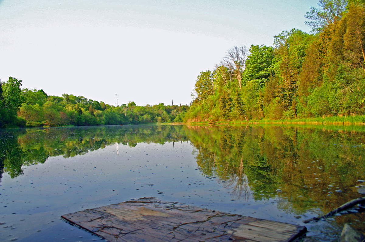 Nothing fires the imagination like the remains of an old mill. Perhaps the most historic mill in the area was Roblin’s Mill, located in Ameliasburgh’s Harry Smith Conservation Area. Built in 1842, the imposing five-storey grist mill was powered by water channelled from nearby Roblin Lake. A short hiking trail in the conservation area about half way down the roadway, takes you past the original site of this historic building. The mill closed in 1920, and Harry Smith of Belleville bought the property and mill in 1947. In 1963, the mill was taken down and reconstructed in Toronto’s Black Creek Pioneer Village, incorporating the same machinery that operated the mill at its original location in Ameliasburgh. In 1983, Smith Quinte Enterprises of Belleville, donated the 7 hectare (17.3 acre) parcel of land to the Prince Edward Region Conservation Authority, (Quinte Conservation) and named it in memory of Harry Smith. The conservation area includes a small pond, originally created to move logs into a log mill that was also located on the property during the 1800s, near the outlet of the pond.
 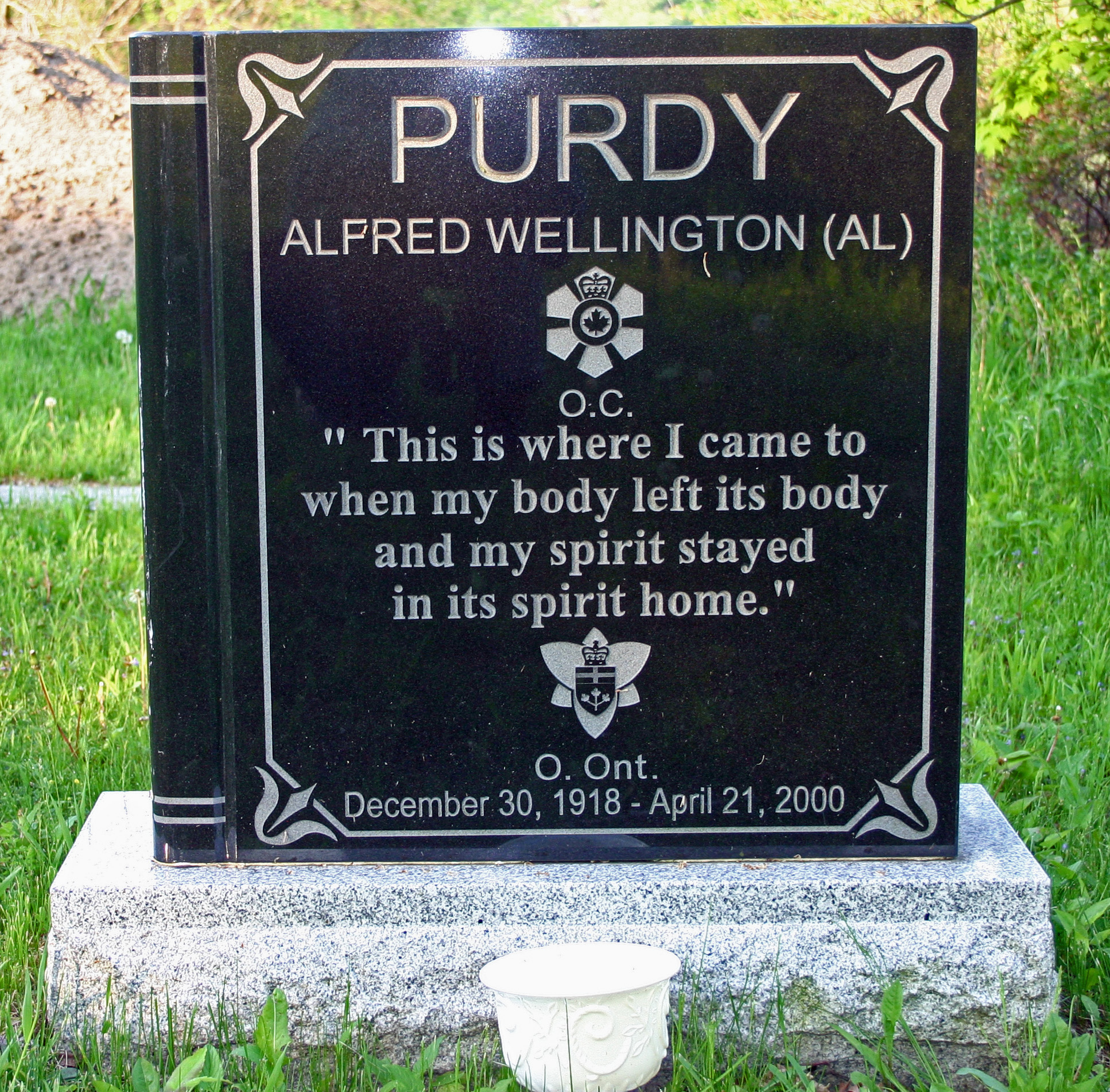 The small, historic, Grove Cemetery, is not part of the conservation area. It is here though where the legendary poet of Ameliasburgh, Al Purdy, is buried. When the area was first set aside as a conservation area, there were more funds available for ongoing maintenance and improvements than there is now. At one time, a 1.5 km hiking trail circled the pond, taking the hiker past the site of the historic Roblin’s Mill, then continued on over a boardwalk through the marshy west end, and climbed the escarpment and continued along the edge of the deciduous woods, eventually crossing a small dam and returning to the parking lot. Between the cemetery and the mill site, a large area had been kept mowed between the millpond and the trail that showed the location of several foundations belonging to three homes, marked by three flag poles. Unfortunately, due to a combination of budget constraints, vandalism and relentless assaults from ATVs, only the parking area is being maintained now. The trail along the
 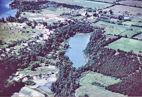 escarpment has been ravaged by ATVs and has become eroded from runoff. The site of the historic foundations has been used at least once as a convenient spot to dump yard waste. The lookout on the escarpment that once overlooked the pond decayed beyond repair and was removed some years ago. The boardwalk likewise deteriorated beyond repair and has been removed. Although volunteers made a valiant effort in recent years to maintain the trail, the repairs became too onerous and the trail has been closed, although there are portions that one can still explore. Likewise, ongoing vandalism has resulted in the outdoor privies being removed. There has been some effort by village residents to keep flowers in the planters and at one time, an attractive rock garden had been established along the trail leading to the east end of the pond. Mother Nature always has the final say, and much of the trail has been encroached upon by trees, bushes and other vegetation. However, one can still wander over much of the area and get a feel for the history here. In addition to the three houses near the pond, east of the cemetery there was another house which later became a cooperage mill. There was also a shingle mill and an ashery. This was indeed a hive of activity during its heyday.
 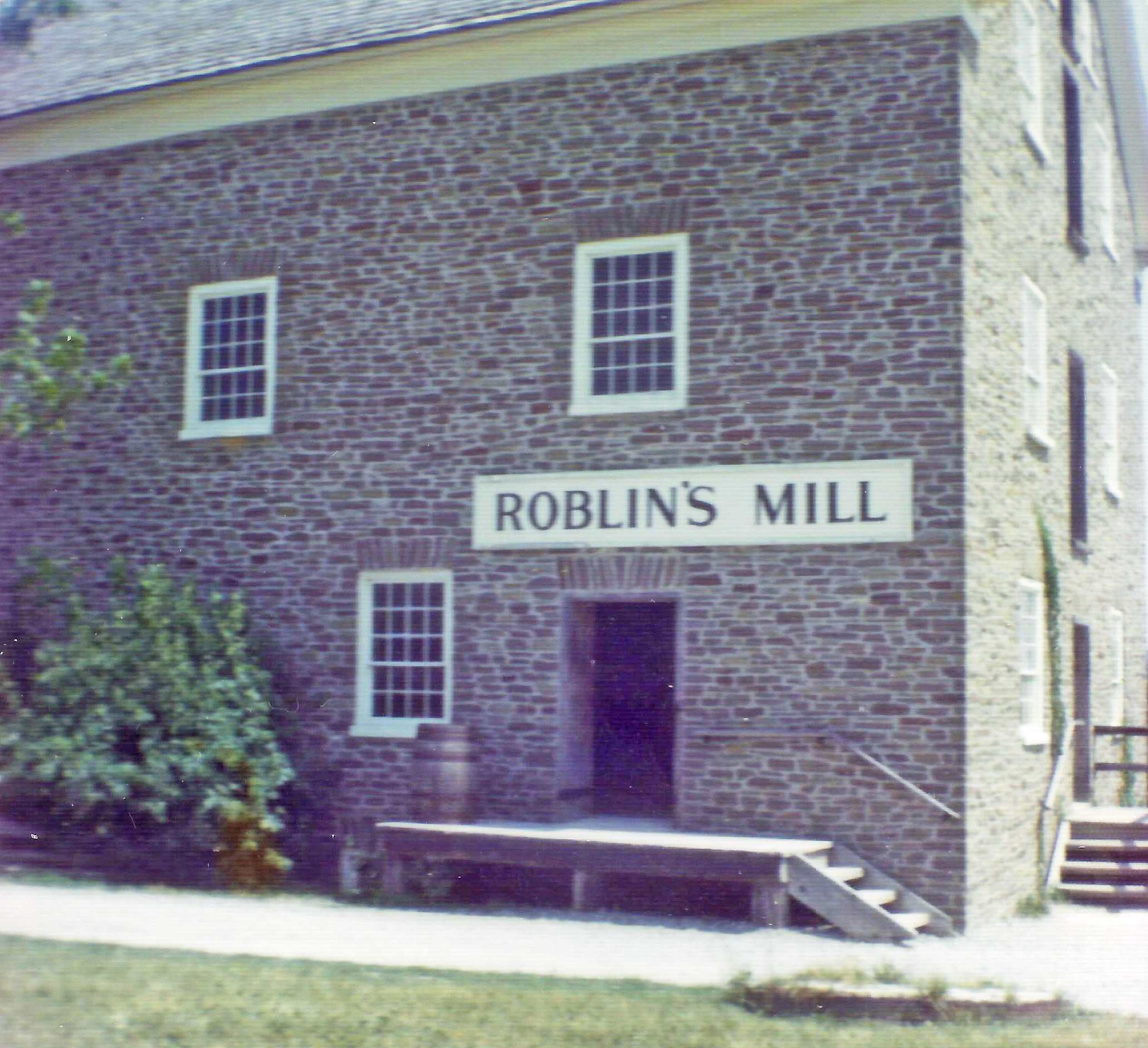 But, it was always the Robin’s Mill that showcased the property. Roblin’s Mill was built in 1842 by Owen Roblin, the grandson of a United Empire Loyalist. When purchased by the Metro Toronto and Region Conservation Authority, the mill was scheduled for demolition. The original timbers, flooring and machinery were salvaged and moved to Black Creek Pioneer Village in 1964. When the Mill was moved to Black Creek Pioneer Village it was established that the original 1848 wheel measuring 30 ft. in diameter was not necessary to achieve the same results at its new site. In 1965 a replacement wheel of red oak measuring 18 feet in diameter was installed. The red oak did not prove to be as resistant to weathering as had been hoped and in August 1984 a new wheel made of white oak and weighing 6000 pounds was installed. Today, Roblin’s Mill is the only operating stone mill in Toronto. Stone for the reconstruction was obtained from the Humber River in Toronto. Roblin’s Mill at its original location operated every day, closing down at 11:55 p.m. Saturday night, and restarting at 6:00 a.m. Monday morning. The mill produced up to 100 barrels of flour a day. Flour would be taken to the Rednersville dock by horse and wagon, to be shipped to American ports. The mill also shipped wheat and rye flour and some buckwheat flour to Montreal.
 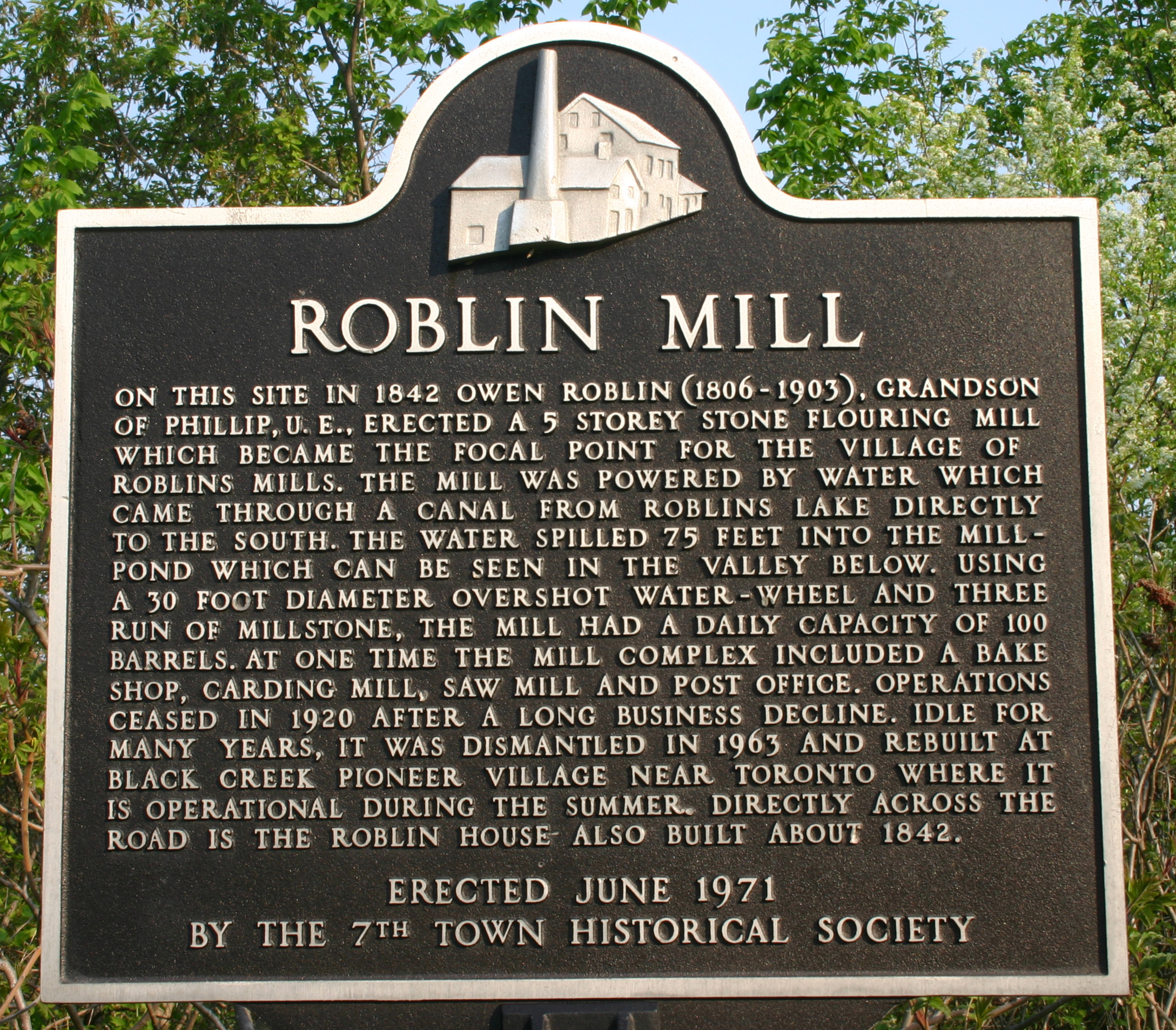 An interesting way to spend an afternoon would be to park at the Ameliasburgh Museum, tour the small historic village that has been set up and get a feel for the local history. Then hike from there, east along the paved county road to Purdy Street which takes you down the entrance to the conservation area. About half way down the hill, look for the start of the trail to the left and begin the hike, and that will take you to the mill location before the trail becomes impassable. While walking along the paved road to the Purdy Street entrance, be sure to stop at the historic plaque and familiarize yourself with the history of Roblin’s Mill. Despite how it has deteriorated over the years due to time and circumstances, Harry Smith Conservation Area is still a wonderful place to visit. Situated as it is down in a ravine, the 17-acre property lends itself well to an impressive variety of wildlife from turtles in the millpond to forest species in the adjacent woodland. * * * * * * * * * * DIRECTIONS: The Harry Smith Conservation Area is located in the village of Ameliasburgh. Entrance is at Purdy Street (shown on map as Hill Street).
Below is the original map of the Harry Smith Conservation Area. Portions of the indicated trail are no longer open, so please use caution, especially on the the escarpment side beside the woods as you could become lost by inadvertently following the trail to the top of the hill which becomes an ATV trail. When in doubt, keep the pond in sight.
